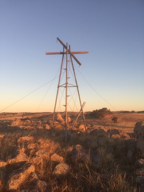
MOORE


Grid Reference DV 506 882 (GDA)
Department Private
Work Depot Private
Region North East
Grading ?
Elevation (ASL) 535m
Height ?
Construction Timbere
Cabin size No cabin on this structure
Public access to site Private property
In use since 194? - 1956
CFA Region 12 - North Eastern
Photo was supplied by David Salau, Wangaratta Fire Brigade's History Group
Please contact us if you have any details about this structure or the other two mentioned below, thanks.

We named this structure Moore, after the property owner who built and used the structure.
David Salau supplied the following information: 16-04-2020 - We have discovered the remnants of an early "private" fire tower on private property near Springhurst. The tower was used in the post war period and manned by the private landholder using a miltary tank range sight. The same gentleman was part of a very early HAM radio operation who used to cross reference fires with other individuals using radios. The tower took in views to the south to the head of the King Valley, Wangaratta , south /west to the Warby Ranges and to the north west covovering Boorhaman, Docker Plains, Springhurst, Rutherglen and Chiltern.
17-04-2020 - The tower is essentially a windmill stand with NSEW oriented timber cross arms. Graeme Moore, original owner of the property used to sit astride the tower on “bad days” and maintain observations.
22-04-2022 - The expansive view is to the RH side of the tower and round to the back of the photographer.
05-05-2020 - It was an old windmill tower with an open wooden deck built on top and secured by wire stays. Graeme Moore built the tower just after the war and operated until 1956 when the Warby Tower was constructed and Lurg tower. Graeme had a post in the centre of the tower to which a mounting plate and a swivelling tank gun site (we believe from a General Grant US supplied tank) was a fixed. I understand that the sight mounting pole sat centre to "half a milk can" marked off in degrees around the lip and a stiff wire pointer aimed at the smoke in order to read off degrees. Being a ham radio enthusiast Graeme would climb down off the tower and transmit the bearings to a fellow ham radio operator when would in turn converse with Mt Stanley tower to get a cross reading. Graeme used a RC16B army transceiver (quarter wavelength - 10ft wire antenna draped in a tree) The ham radio operator in Springhurst also had a fire observation platform atop his water tank. We also have a pic of this. We believe another bloke by the name of Tirrel somewhere out from Rutherglen / Browns Plains also had a similar set up. Between the three "towers" visual coverage was able to be provided across the plains north of Wangaratta as well as the dead spot toward the Warby Ranges and south ward to Taminick Gap and the country toward the head of the King Valley not able to be spotted from Mt Stanley. We are still pursuing info about the observation platform used by Tirrel.

Back to North East
Back to Victorian Towers
Back to Home Page