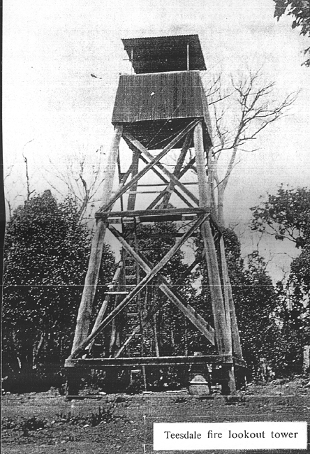
TEESDALE
| Grid Reference |
-32.723840, 116.034809 |
Department |
DEC |
Work Centre |
? |
District |
Perth Hills |
Grading |
? |
Elevation (ASL) |
330m |
Height |
12m |
Construction |
Timber |
Cabin size |
? |
Public access to site |
? |
In use since |
1935 - 1961 |
Scanned copy supplied by Paul Jones. Source is unknown.
Tower was destroyed in the January Dwellingup fire in 1961
In a Departmental document from 5th April 1961 it states: Replace with 60ft tower on a new site yet to be fixed but probably 10-15 chains west of the original site.
A tree in this vicinity has been pegged and it is reported that a new site will offer definite advantages.
So far, we have found no evidence that the replacement tower was ever constructed.
In Nov 2019, Max Le Clercq reported: Co-ordinates approx - no remains of tower, destroyed in 1961 fire. Was located on Teesdale Hill just west of Dwellingup.
The following quote is from an article in The Western Australian from Wednesday 5th Mar 1935, page 16:
During the past 12 months the scope of fire detection throughout the forest areas of the South-West had been extended by the erection of four additional fire towers.
One near Sawyer's Valley, one at Teesdale (near Dwellingup), one on Mt. Keats and one on Mt. William, in the Yarloop area.
Back to Swan Region
Back to Western Australia Towers
Back to Home Page