MT. DOM DOM


Grid Reference CU
Department Melbourne Water / DEPI
Work Depot Healesville
Region Port Phillip East
Grading Secondary
Elevation (ASL) ?
Height ?
Construction Tree
Cabin size ?
Public access to site ?
In use since 194?
CFA Region 12 - North Eastern
Photo (1940) is supplied by Melb. Water (MMBW)
Below is a description of the above photo at the display at Dom Dom saddle on the Black Spur.


This tower no longer exists. It was a small tree tower immediately north of the central - northern boundary of the Maroondah Water Catchment. It was a secondary tower with provision for AM radio contact with Mt. St. Leonard.


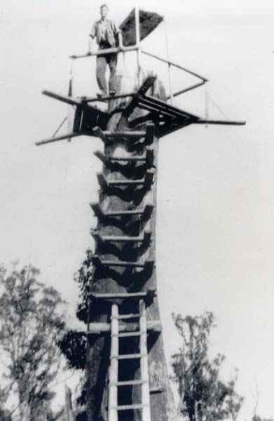
Mt. Dom Dom in 1951. Photo was supplied
by the Melbourne Bushwalking Inc.
Note the cabin improvement and a new ladder.
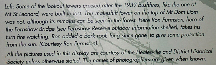
Mt. Dom Dom in 1920s. Photo obtained in March 2022 from the Healesville & District Historical Society
and used with permission. We have no further evidence or documentation about the tower in the 1920s.
The description with the 1920s photo from the Healesville & District Historical Society stated: The Lookout, Mt. Dom Dom, Narbethong. With the tall trees in the background, we are not sure if it actually was a fire tower or a scenic lookout tower, looking down into Narbethong and towards Marysville. If you can add any more information, please do not hesitate to contact us.

Back to Port Phillip
Back to Victorian Towers
Back to Home Page