Photo supplied by Michael Bleby. This tower no longer exists.
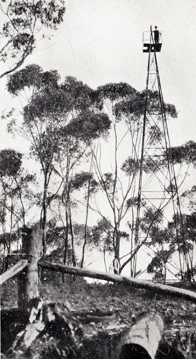
Below is an extract from the Fire Tower chapter of a book, Forestry Tales, that was written by Michael H. Bleby OAM. It is used with permission, thanks Michael. My first encounter with a fire tower was as a Forestry student in 1967. Those of us on Forestry studentships with the State Government were assigned to various Forest Districts for work during the University vacation. My posting to Wirrabara Forest in the mid north of South Australia on this occasion included an introduction to Fire Season activities that were to be a part of my professional career for the next 40 years. Fire detection in the Northern District at that time was quite different from the other Forest Regions of the State. First reports of fire were nearly always by telephone to the Office or if it was after hours, the night switched phone to the Forester’s house. Reports usually came from a neighbour or someone with a vantage point. The technicians at the 'Bluff' TV tower on a nearby high point of the Southern Flinders Ranges often called in with a smoke sighting as they had a commanding vista from their station. Sometimes the description meant the location needed confirmation and another sighting was needed. For this purpose there was a large open windmill like tower with a platform to stand on at the top, located on the ridge at the back of the District Forester's residence at the Headquarters. Fire lookout towers have an alidade, usually made of brass, set and fixed at due North. Using a rotatable sighting arm, the bearing of a smoke column from that position can be read from its 360 degree compass rose. Once communicated to the office with an estimate of the distance from the tower, it is a simple matter of triangulation using 2 or more bearings plotted on a wall map, to fairly accurately pin point the location of a fire.
Although somewhat crude, the Wirrabara tower did the job on the few critical occasions a cross reference was needed. A quick run up the ridge and a climb up the tower would clarify the location of the smoke report. Current day Occupational Health and Safety would probably rule out standing on the narrow platform and hanging on with one hand to determine a bearing, let alone climbing up a narrow uncaged ladder.